

Places in the Empolese Valdelsa
Filter/Filtra
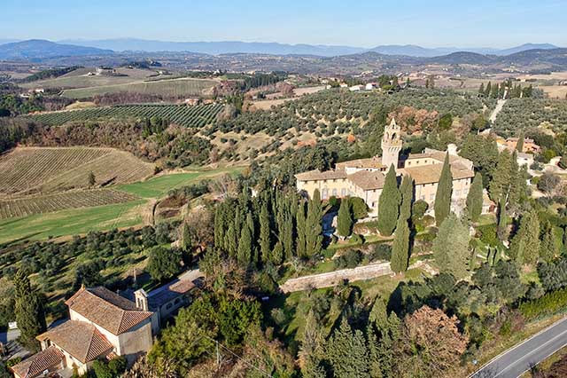
Today Montegufoni is a villa in the Baroque style; however its origins are much more ancient. In this place there once stood a castle that was destroyed by Florence in the early 12th century. There is no more information about Montegufoni until the 14th century, when the Florentine family of the Acciaioli took over the ancient site, in order to convert it into a country residence. Leonardo depicted it in the forms attained by the Acciaioli transformations, when Montegufoni had the appearance of a fortress, building complexes typical of the Florentine countryside during the 14th-15th centuries. Only in the 17th century was the fortress of the Acciaioli transformed into a genuine villa.

Montelupo is represented by Leonardo in the famous view of the Windsor Castle Collection RL 12685. At the confluence of the Pesa with the Arno, Leonardo depicted the hill of Montelupo with an upper part, the castle, and a lower part, also equipped with fortifications. In 1336, the village of Montelupo was surrounded by walls, and this was the form in which Leonardo represented it, in the early 16th century. In Leonardo’s map, the Via Pisana, coming out of the gate on the Pesa, can be seen quite clearly, heading, in a straight line, toward Pontorme and Empoli.
The castle of Monterappoli, an ancient fortified town of the Counts Guidi, was represented by Leonardo still surrounded by defensive walls with towers. In fact this was the appearance that it must still have had at the beginning of the 16th century. Of the castle of Monterappoli and of its villages, described in numerous fiscal sources and in the statutes of the small rural municipality, nothing remains other than the castle church, San Lorenzo, preserved in late forms among the houses of the small hamlet of Monterappoli, where the Via del Castello recalls the origins of the small town of the Valdelsa.
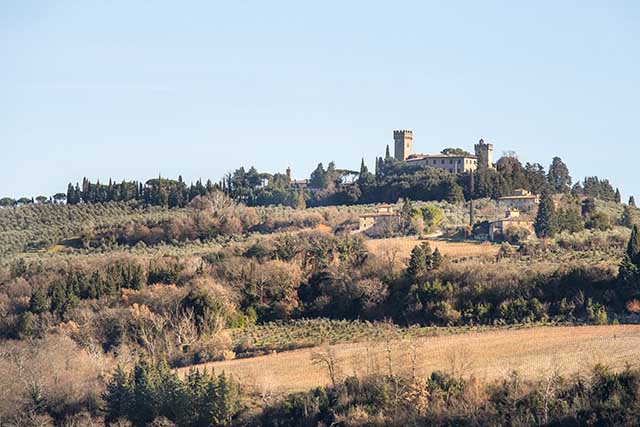
The place named monte sighipertuli / monte spertuli in the most ancient documents seems to have been equipped with fortified structures already from the end of the 11th century, with the involvement, albeit indirect, of Count Ughiccione of the Cadolingi. Of the ancient castle dating from the origins, which must have occupied the summit area of the hill of Montespertoli (now Sonnino property), no traces remain. At the beginning of the 16th century, Leonardo represented Montespertoli as a fortified village: the most developed part of the Late Medieval town built along the Via Volterrana must have appeared, in fact, as a dense and compact agglomeration.
The 50-year anniversary of the Fucecchio Museum also falls in 2019, the year of Leonardo. For this occasion the museum has been enriched by a new permanent exhibition that will illustrate the formation of the medieval landscape around Fucecchio, an ancient Cadolingi castle on the Via Francigena that Leonardo depicted in one of his most famous maps, in the form it had reached during the 14th century, with the walled villages and the towered hill of the Rocca Fiorentina. Leonardo is the guiding theme of the exhibition Alle radici di un luogo leonardiano: una signoria e il suo paesaggio (At the roots of one of Leonardo’s places: a lordship and its landscape) with which the new permanent section opens. The transformations of the landscape, reconstructed with digital instruments, accompany the visitor through the centuries of the history of this "Leonardian place".
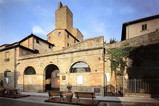
In the heart of Vinci a unique museum was founded in the 1990s, the first to be dedicated to this figure in all of his complexity. The Museo Ideale has earned official recognition as an institution of great public benefit by the regional government of Tuscany. To mark the fifth centenary of the death of Leonardo, the museum has been completely refurbished; its permanent exhibitions have been renovated and a special exhibition of works of particular importance and value is on display.
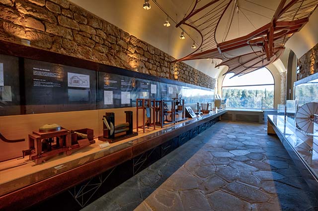
In the heart of Vinci, at the Palazzina Uzielli and the Castle of the Counts Guidi, the Museo Leonardiano houses the oldest collection of models of Leonardo’s works as scientist and engineer, consisting of more than 80 wooden reproductions and digital animations. A center for study and documentation, together with the Biblioteca Leonardiana, the Museo Leonardiano pursues research on Leonardo's technical and scientific work within the context of Renaissance culture, in significant collaborations with national and international university and research institutes.
The vastness of Leonardo's interests and studies—from construction site machinery to futuristic devices for textile manufacturing, from projects for war technology to those allowing humans to soar in flight, or to move about, above or below the water, and on to experiments in optics and anatomical studies—these are all fully documented in the Museum.
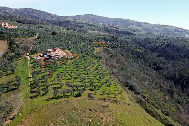
Leonardo da Vinci took a great interest in agriculture, and recorded observations on agricultural techniques in his notebooks, complete with sketches of farming tools and olive presses. Since Leonardo himself owned some vineyards, he made many notes on the cultivation of grape vines and enology. To document this particular aspect of his activities, the Museo Ideale Leonardo Da Vinci has created a separate section, “The Renaissance of Wine”, housed in a beautiful 16th-century villa in Sant’Ippolito in Valle, not far from the main museum located in Vinci.
Orbignano has very ancient origins. It was a village of the bishop of Pistoia, and maintained this link until the 13th century, as a small rural municipality in the district of Pistoia. In Leonardo’s time, however, this part of Montalbano had already passed under the government of Florence, over a century earlier, so that the lands at Orbignano belonging to the da Vinci family were then situated within the municipality of Vinci. The Costereccia farm in Orbignano became the residence of the branch of the family of notary Domenico di Ser Piero da Vinci, one of Leonardo's half-brothers, for more than two centuries. All his descendants, and perhaps Domenico himself, were buried in the cloister of the church of Santa Maria al Pruno.
The Palazzo Pretorio in Certaldo will be hosting, on the occasion of the Leonardian Year 2019, the exhibition Paesaggi in trasformazione tra il Medioevo e l’età di Leonardo (Landscapes in transformation between the Middle Ages and the age of Leonardo). Suggestive virtual reconstructions show the evolution of the landscape of this part of the Valdelsa, from the Middle Ages, before and after the foundation of the mythical city of Semifonte, on up to the time when, in the early 16th century, Leonardo represented, in one of his most famous maps, the Elsa and its system of fortified villages, among which we can recognize the turreted profile of Certaldo.
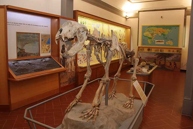
The Paleontological Museum of Empoli offers us the possibility of discovering the origin of the geological formations that aroused so much interest in Leonardo. Among the folios of the Codex Leicester, Leonardo makes many references to the gravels of Montelupo and Capraia, and to the bluish muds of Collegonzi, very rich in nichi (fossil shells). The museum conserves, among others things, collections of Pliocene malacofauna (mollusk life) discovered at Spicchio sull'Arno, near Collegonzi, the very same nichi observed, collected, and drawn by Leonardo.
The small fortified village that Leonardo indicates with the name of "pietra" depicts a place that has now disappeared, the ancient castle of Pietra. At the beginning of the 12th century, when it appears for the first time in written sources, it must have belonged to the bishop of Volterra. There are few remaining ruins of the ancient castle, which must have been fortified with defensive walls and towers, visible today on the site of the "La Pietrina" Sanctuary at the locality of Palagio (Montaione). We do not know at what point the locality was definitively abandoned, but one thing certain is that, at least during Leonardo’s time, it was still inhabited, and had an appearance similar to a turreted castle.
Pietramarina is an ancient locality, situated at one of the highest elevations of the southern ridge of Montalbano. This place, where we can see the remains of a fortress-sanctuary dating back to the Etruscan period, and a curiosity, the renowned "Masso del diavolo", was called sasso marino in the 16th-century. Leonardo must have known this part of Montalbano: from here he could descend towards Bacchereto and, especially, toward the family home of his paternal grandmother. In the famous view of Montalbano in Codex Madrid II, f.23r, Leonardo reports the toponym Fornia, which corresponds today to the name of a farm near Pietramarina.
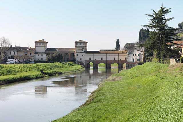
The Medici bridge at Cappiano has always held a special place in the history of the Cerbaie. During the early Middle Ages it was one of the stages of the Via Francigena. The resting place was called Aqua Nigra, indicating, at the time, the Usciana river, the only effluent of the Fucecchio marsh. The bridge, an obligatory crossing of the pilgrimage route, became strategic during the municipal period when the cities of Lucca and Florence faced off with each other in this area. At the end of the 13th century, the Cappiano bridge was fortified with a masonry tower, and it was in this form that Leonardo depicted it, before the radical reconstruction commissioned by Cosimo I.
Today, Pontorme is a small hamlet of Empoli that the intense urbanization of recent times has completely engulfed. The form of the ancient castle of the Alberti, and of the small village that grew up outside the eastern gate along Via Pisana, can be recognized only by looking into the network of the streets revolving around the church of San Michele Arcangelo. Leonardo depicted the small fortified village of Pontorme in the form it had reached during Florentine domination, when it was surrounded by new walls. On one of the towers, the civic bell, created in 1278 by magistri campanari who came from Florence, resounded.
The ancient community of San Bartolomeo a Streda was situated, from the origins, on the border between the territories of Cerreto and Vinci. On the slopes of the gentle hills on which the church of San Bartolomeo lies today, well preserved in the aspect that it must have had, roughly, in the times of Leonardo, the da Vinci family owned its most productive vineyards. In the list of properties declared by Leonardo's father in 1469, was the podere della chosta (Chosta farm), with an overall value of 1000 florins, and which, according to what was declared, yielded 40 barrels of wine per year.
The geological area that, during Leonardo’s time, also included the community of San Donato in Greti, the ancient district of one of the churches belonging to the Counts Guidi in the 13th century, is characterized by clays and Pliocene levels, rich in fossils of marine origin. It is located near Collegonzi, where Leonardo observed the famous "nichi" (fossil shells) of the sea. At the time of Leonardo, there were several furnaces in this area for the production of bricks, such as that in the locality of Mercatale, where Leonardo's stepfather, the renowned Accattabriga, also worked.
The church of San Lorenzo in Arniano belonged in the middle of the 13th century to the powerful family of the Counts Guidi. It was located on one of the hills of the Montalbano slope facing the Val di Streda, and today there remains an ephemeral trace in the structures of a ruined farmhouse along a local road that still bears the name of San Lorenzo. Leonardo knew these places very well, as his family owned lands and estates in the area. The waterways of the community of San Lorenzo in Arniano were depicted with great precision by Leonardo, who had projected the construction, downstream, of an artificial lake.