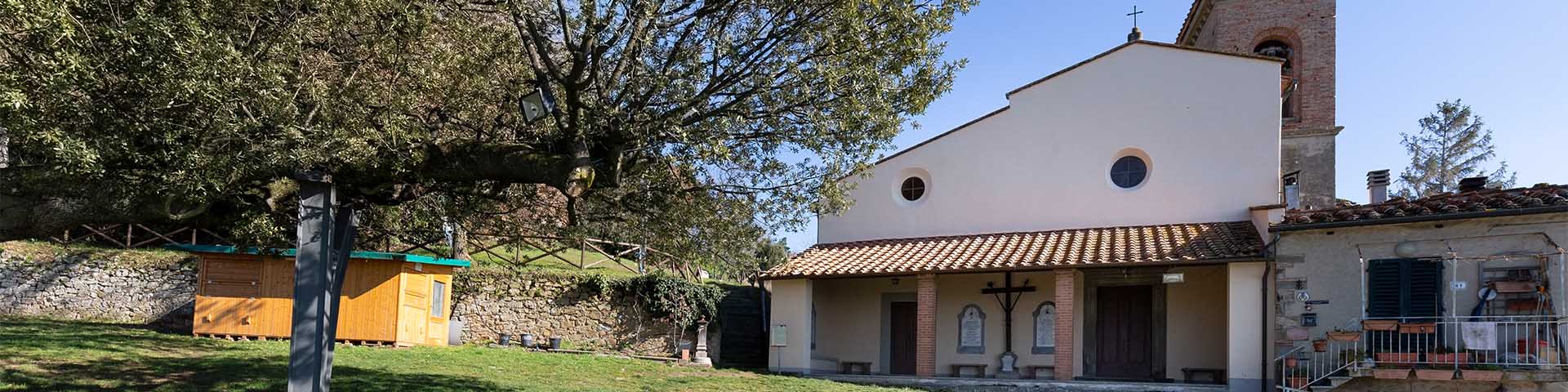
The church of Santa Maria in Faltognano belonged to the parish church of Greti since the 13th century, but the current building is the result of a radical 19th-century reconstruction. In the community of the church of Faltognano, some of Leonardo’s family’s estates stood, still recognizable today in the names of the small groups of farmhouses, such as La Noce, Il Capannile, and Podere Santa Maria. Leonardo must have known these places very well. On the Faltognano side, in fact, flowed the springs of some of the waterways Leonardo included in a project for the construction, downstream, of an artificial reservoir. Just below the church of Santa Maria flows the source of the Leonardian Rio di Lecceta, while a bit further to the east passed the Rio di San Lorenzo, all depicted by Leonardo da Vinci on the three maps dedicated to the project of the reservoir in the locality Serravalle in Val di Streda. These areas can easily be reached, by choosing, from among the "Paths of the Genius", the path "Anchiano, Santa Lucia, and Leccio di Faltognano", Or by choosing paths 10-14 and the connected local roads, on the municipality of Vinci’s "Hiking Trails Map".


-
Home

-
Places
-
Metropolitan City of Florence
- Municipality of Vinci
Santa Maria a Faltognano
The first attestation of the locality Faltognano is very ancient, dating back to the first decades of the 12th century. The place called Faltuniani is listed among the places that defined the diocese of the castle of Vinci in 1114. The document in question is the act with which Count Guido V Guerra and his wife Imilia (formally) sold the castles of Colle di Pietra, Cerreto, and Vinci, with their respective castle territories (curie) to the abbot of San Salvatore di Fucecchio. The information is very interesting, because it would place Faltognano in the territory dependent on Vinci as early as the 12th century, even though constantly in a border position. The first attestation of the church of Faltognano is, instead, much later. The ecclesia S. Marie de Faltognano begins to be mentioned only from the end of the 13th century, in the tithes for the years 1276-1304.
The late 16th-century map of the Captains of Parte Guelfa dedicated to the community of Santa Maria a Fatignano (this was the name used by the Florentine officials) shows the network of rural roads in the service of the small towns of Montalbano, which at the time constituted the ecclesiastical district of Faltognano. It was a small parish territory between the ridge of Montalbano and the valleys of the streams that were called, at that time, Rio di Lecceta and Rio di San Lorenzo. The Rio di Lecceta had its sources in the vicinity of the place which, on the 16th-century map, is called fondaccio [di] quelli del sasso (dregs of those of Il Sasso): the 19th-century name of this watercourse is, in fact, “Torrente del Sasso”. The Rio di San Lorenzo originated farther to the east, but flowed just below Faltognano and took its name from the church of the nearby community of San Lorenzo in Arniano. These are the waterways that Leonardo drew in his three maps (Windsor Collection RL 12675 and RL 12676, Codex Atlanticus f. 952r) that remain of the project he dedicated to the places of his origins. The three drawings represent the complete hydrographic system in descent from Montalbano, on the slope of Faltognano, and included the watercourses that primarily crossed the territories of the communities of Santa Maria in Faltognano and San Lorenzo in Arniano. The project involved the damming, downstream, of the three watercourses, to create an artificial reservoir in the place that today bears the name of Serravalle. The hydrographic system of the San Lorenzo and Lecceta brooks is represented with extreme precision: Leonardo knew these places very well, as he had been able to frequent them during his early youth in Vinci. His family owned several farms, in fact, in the community of Faltognano.
In this area stood some of the farms owned by the da Vinci family, to be specific, in the localities of Capannile, La Noce, and Santa Maria Nuova. Two of these places can be recognized perfectly in the 16th century map and are associated with the drawing of a farm house (capannile) and the small chapel at a crossroads (vergine della noce, or the virgin of the walnut). The same place names are still used today to indicate groups of houses or simple farmhouses situated along the local roads of Faltognano. The third property of the da Vinci family located in the community of Faltognano, the podere di Santa Maria Nuova (farm of Santa Maria Nuova), is probably to be identified with the podere Santa Maria documented in the 19th century with this name, located a short distance from the church of Faltognano. Of the ancient church of Faltognano there is no trace: the current building is, in fact, the result of the complete reconstruction carried out in 1895. However, the sketch that depicts it in the 16th-century map gives the appearance of a small church with a single hall and a gable roof surmounted by bell gable. In front of the façade, pierced by a single window above the portal, we can see a stairway that gave access to the main streets of the place: one for Santa Lucia a Paterno and one for the Palagio and the valleys below. The road that led to the Montalbano ridge, and from there to Vitolini, also started from the church of Faltognano.
Texts by
Silvia Leporatti / English translation by John Venerella
Related resources
Gallery


Related resources
Gallery