X
Capraia

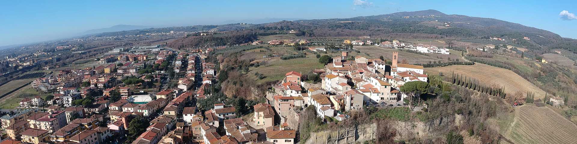
The castle of Capraia was drawn by Leonardo on the southern slopes of Montalbano, in the bird's eye map RL 12685 of the Windsor collection, which represents in detail the stretch of the Arno west of Florence. Its appearance is that of a fortified hill, surrounded by a curtain wall fortified with eight wall towers. The same characteristic details can be found in the less well-known, recomposed drawing from the Codex Atlanticus, folios 765v-766r, where he depicted, with a stroke of red chalk, the profile of Montalbano seen from the bend of the Arno, with the castle of Capraia on the right and the one in which, on the left, perhaps, a part of Montelupo can be recognized. Leonardo knew very well these places and their nature: he mentions Capraia and Montelupo in several passages of his observations on the origin of the geological formations of the Lower Valdarno.

Capraia is mentioned for the first time in 1090 and the expression used in the document confirms that it was already a fortified center: "caprariam oppidum". The mention of an oppidum suggests that, at least since the end of the 11th century, the locality had the function of a military stronghold functional to control of the Arno and of the paths connecting the two shores. The presence, among other things, of more than one care facility connected to this place would confirm this function. The document from 1090 recalls, in fact, a hospitale at the oppidum of Capraia, owned by the powerful rectory of San Zenone a Pistoia, explicitly dedicated to the welcoming of pilgrims and wayfarers. At that time, and precisely in 1105, the Pistoia bishopric owned a church in the immediate vicinity of Capraia (cappella de Capraia), also confirmed in the following centuries. The castle of Capraia seems to be connected, from its origins, to a foothill itinerary that must have connected the city of Pistoia with the Lower Valdarno, and in particular with the possessions of the cathedral of San Zeno in the area of ​​Greti. The area of ​​Greti, in fact, which occupies the middle part of the Montalbano slope stretching from Castellina to Cerreto Guidi, belonged, since it is origins, to the diocese of Pistoia. In fact, the easternmost parish churches of the Pistoia area were those of Sant'Ansano in Greti and that of Santa Maria a Limite.
However, from the second half of the 12th century we know that the castle belonged to the Alberti counts. Capraia appeared, in fact, among the castles of the Valdarno confirmed by Federico Barbarossa to Count Alberto IV in the famous diploma of 1164. The castle still belonged to the main branch of the noble family a few decades later, during the Semifonte War. In 1184, Count Alberto IV had to swear a heavy cession to Florence: among the clauses, in addition to breaking down the defenses of the Valdarno castles of Semifonte, Pogni, and Certaldo, the ceding of a tower of the Capraia castle was ratified, which the Florentines could use, or raze to the ground, as they would have it. The rocky cliff on the Arno on which Capraia stood was, at the time, extremely strategic for Florence, which had intentions of expanding its comitatus in the direction of Pistoia and Lucca. The boundary of the Florentine territory stood right at the Arno narrows, where the Montalbano spurs projected, on which the city of Pistoia had already planned, at the end of the 12th century, the consolidation of its district. Soon the castle of Capraia would be disputed between these forces in the field, until final absorption by the city of Florence.
At the beginning of the 13th century, Capraia was already an integral part of the territory that the city of Pistoia was consolidating as its districtus. The official sources of the Pistoia area confirm the commitment sustained by that city to maintain the effectiveness of the castle. A witness of the time claims to have worked for the municipality of Pistoia on the arrangement of the defenses of some castles of Montalbano, including that of Capraia, a place of considerable strategic importance, and advanced point of the Pistoia districtus, on the border with Florence. In Capraia, formerly an Alberti castle, Count Guido Borgognone of the Alberti family lineage had taken up residence with his sons Rodolfo and Anselmo. This branch of the family had associated the noble title with the small castle of the Valdarno: they were the so-called Counts of Capraia. A series of documents from the year 1204 are particularly clear in describing the strategic importance of this segment of the Arno and the forces that then opposed it. At that point in time, the expansionist ambitions of Florence and Pistoia had halted on opposite banks of the Arno: where the ancient fortress of Capraia and the new castle built by Florence, Montelupo, then in construction, stood, facing each other. The first document of 1204 is, to all of effects, a pact of non-belligerency, with the Florentine consuls on the one hand, and on the other, the consuls of Pistoia, together with the Counts of Capraia and the inhabitants of the castle. Each side promised not to attack the castle on the opposite side, formalizing, in essence, a boundary line that coincided, at that point, with the River Arno. Florentine pressure on the left bank, materialized in the construction of the new castle, must have solicited the urgency of the association between the Counts of Capraia and the municipality of Pistoia, intent on defending the most advanced point of its district in the Lower Valdarno. A second document, also from the same year, explains in detail the terms of this association. This was an oath of mutual defense, which would have constituted, from then on, a formal commitment between the city of Pistoia and the Counts of Capraia. The consuls of Pistoia would have defended the noble family from the Florentine danger, asking in exchange the use of a tower, probably the same tower that a few decades earlier, in 1184, had been claimed by the Florentines at the time of the Semifonte War. The tower of Guido Borgognone was to represent the strong point of the castle. The Pistoians promised to return it to the Count after the end of the contrasts with Florence promising, among other things, not to build any new fortifications in Capraia that exceeded the height of that tower. On the other hand, the counts promised to defend the citizens of Pistoia in the area under their jurisdiction, the territory of the castle of Capraia, which however they recognized as part of the districtus of that city. They would not permit, under any circumstances—so they said—Pistoia to lose the castle of Capraia or its fortitudines. Only a few months later, however, the family of the Counts of Capraia ceded to the pressures of the city of Florence: a new covenant would sanction the passage of the castle and, above all, the famous tower of Count Guido Borgognone to the Florentines. Finally Florence would be able to take advantage of the important strategic point on the left bank of the Arno. The community of men of Capraia, on the other hand, was forced to pay to Florence the tax that formally sanctioned their membership in the Florentine comitatus. However, just before the middle of the century, the rural municipality of Capraia was still counted in the liberum focorum of the municipality of Pistoia, or the census of the family heads of the population of the city district. But the small number of "fochi" (homes) registered—only five, because others had moved to the nearby town of Castellina iusta Arni—seems to show a yet poorly defined situation of that community's position in relation to the territories controlled by the two cities.
When the imperial troops, with their allies of Pisa, Lucca, and Pistoia, found themselves moving against Florence in 1249, the castle of Capraia assumed the function of stronghold of the Florentine resistance. Counts Rodolfo and Anselmo di Capraia, who had led the defense operation on behalf of the city of Florence, were executed in Naples. Therefore, in the second half of the 13th century, the small castle of the Valdarno became an integral part of Florentine territory. After Florence's purchase of the Guidi castles of the Vinci area, this part of Montalbano, which in ancient times took the name of Greti, entered to be governed by the regime of Florentine administration. In 1332 Florence changed the organization of the peripheral governments by merging the leagues of Cerreto and Vinci with that of Capraia, thus uniting together all the communities of ancient Greti (Capraia, Vinci, Cerreto, Musignano, Colledipietra, Collegonzi, Linari, Campostreda). The community of Capraia, as we can deduce from later sources, must have included, in addition to the community of Santo Stefano a Capraia, the communities of San Pietro a Bibbiano, San Pietro a Castra, San Biagio alla Castellina, San Jacopo a Pulignano, and the community of the parish church of Santa Maria a Limite. In 1366, Capraia appears among the fortresses that were the object of the recognition of the defensive apparatus on the part of the competent magistrates. The report of the "Castle Officers" mentions the tower of Capraia, probably the ancient tower of the Counts of Capraia, repeatedly mentioned in the documents of the 13th century. The defensive walls were equipped with at least two gates, one called the Porta di Sopra (upper gate), probably on the north side of the castle, and a second gate called Porta Vecchia (old gate), with obvious reference to the existence of a more ancient defensive system. The walls were not in good condition, if requests were made for the construction of wooden fences where the walls were falling apart, as well as for the restoration of wooden walkways, merlons, and parapets. The castle structures, which must have suffered damage following the war episodes that lasted until at least the early 14th century, were probably restored and maintained under the Florentine government. In the early 16th century, in fact, Leonardo depicted Capraia as a well-fortified castle.
There are several Leonardo folios on which Capraia appears. It is for example perfectly recognizable from the toponym on the map RLW 12685, which represents in detail the lower valley of the Arno and the Montalbano mountain range above the lake of Bientina and the Fucecchio marshes. Leonardo situates Capraia on the southern spur of Montalbano, overlooking the Arno, facing Montelupo. It is represented in the form of a castle fortified with walls, along which there are at least eight wall towers. Both the drafting of the chiaroscuro in the rendering of the rocky spur and the curvilinear section on which the towers of the northern side of the defensive curtain rest, seem to be traced with the intention of representing the castle's morphology, perched in a strategic position after La Gonfolina gorge. The same form of the village is found, but from a different angle, in the drawing recomposed from folios 765v-766r of the Codex Atlanticus, a sort of skyline of the Montalbano massif on the curve of the Arno seen from the North, with the castle of Capraia on the right, and one on the left of which a part of Montelupo is perhaps recognizable. Leonardo must have observed Capraia still equipped with the defensive structures of the previous period.
The castle of Capraia at the time of Leonardo must still have been fortified with the principal elements of defense. The Florentine government prescribed, as has been seen, the restoration of the defenses that, where necessary, it continued later. The appearance of the castle in the time of Leonardo is confirmed by a map of the Capitani di Parte Guelfa of the community of Santo Stefano di Capraia, dated 1585-90. The quadrangular shape of the castle is recognizable, surrounded by massive walls, on which an arched door opens on the southern side. A second access seems to be located to the north, near the castle church, perhaps the so-called "Porta di Sopra" mentioned in the 1366 report. On the opposite side, however, near the corner that looks in the direction of the Arno Valley, we can recognize a third access (postern?), from which a gradated path descends toward the river. The inhabited area, although surrounded by walls, seems to be only partially urbanized: in the portion located near the South Gate, the specifics of the use of spaces for "vegetable garden" and "lawn" can be read. The current town of Capraia preserves several traces of the castle's fortified structures: they were made of river pebbles, only rough-hewn, arranged in rows, while the parts in mixed material with bricks refer to the numerous works of restoration that took place during the Late Middle Ages and the early Modern Age.

Leonardo's scientific observations in the field of geology and paleontology are mainly found in the Codex Leicester, and concern various parts of Tuscany. Several passages of the codex concern the area of ​​Capraia, where Leonardo had observed the conglomerates of Plio-Pleistocene origin that he called "ghiare" (gravels). Leonardo demonstrated a level of interpretation of the phenomenon representing considerable acumen, with respect to the geological sciences of his time, which were still stuck on the theories about the Great Flood; he illustrates with great clarity the origin of those geological formations that he calls, on the basis of the dimensions of the individual inclusions, "gravels", "sands", and "muds". The movement of the waters of the sea, which once came to lap the slopes of Montalbano, up to La Gonfolina, was the cause for the formation of the gravels and the sands, fragments of rocks brought to the shore of the Valdarno sea by rivers, and made roundish, though with different caliber of nuclei, by the motion of backwash. This can be seen, according to Leonardo, in different parts of Italy, from the Alps around Como, to the Po River Valley, and even in the Arno Valley, on the slopes of Montalbano, around Montelupo and Capraia (Codex Leicester, ff. 6A-31v.). Leonardo continues, to explain that the Arno at that time flowed into the sea at the position of La Gonfolina, depositing on the slopes of Montalbano the conglomerates of pebbles and gravels: “come Arno, che cadea della Golfolina a presso a Monte Lupo, e quivi lasciava la ghiara, la quale ancor si vede che s’è insieme ricongielata "like the Arno, which descended from La Golfolina, to nearby Monte Lupo, and there it left the gravel, which we can also see has been reunited together."

.

Texts by
Silvia Leporatti / English translation by John Venerella
Related resources
Gallery
Related resources
Gallery