

Artimino
Artimino, now in the Commune of Carmignano, was an Etruscan city overlooking the Arno Valley and the Golfolina pass, whose importance is evidenced by Leonardo in the Codex Leicester. He represents it on map RL 12685 (Windsor Castle) and indicates it in Madrid Ms. II (f. 23r). It conserves the Romanesque Pieve di San Leonardo and parts of a medieval stronghold. The Medicean villa built by Buontalenti for Grand Duke Ferdinando I, in the second half of the 16th century, is an imposing structure.
Bacchereto
Bacchereto, in the Commune of Carmignano, was an important centre of artistic ceramics, in which Leonardo's paternal grandmother and then his father possessed farms and a kiln; it may be presumed that Leonardo's experience of art began here.
Capraia
Capraia was an ancient stronghold that - as an outpost of Pistoia - controlled road and river traffic at the confluence of the Pesa with the Arno, where Montalbano terminated opposite the stronghold of Montelupo built in 1203 by the Florentines. Leonardo represents it on map RL 12685; without naming it, on the recomposed folio of the Codex Atlanticus (765v + 766r); he indicates it in Madrid Ms. II (23r), again in relation to the project for deviating the Arno; and mentions it in Madrid Ms. II (f. 15r) along with the nearby "Monastero" (that is, the remains of the Monastery of San Giorgio with its bell tower, still recognisable today on the right bank of the Arno) and in the Codex Leicester (6A-31v) for its geological characteristics.
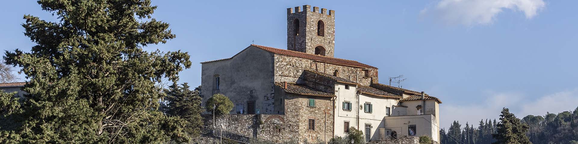
Carmignano
One of the major historic-artistic centres of Leonardo's Montalbano, bordering on Vinci, Carmignano conserves the fortress and the church of San Michele e San Francesco dating from the 15th century, with Pontormo's "Visitation".
Castellina
Castellina is a place of Etruscan origin, an ancient stronghold close to today's Limite sull'Arno, the administrative centre of the Commune of Capraia e Limite (bordering on that of Vinci), on the connecting road along the right bank of the Arno, from Vinci to Montelupo. Leonardo represents it on map RL 12685 and indicates it on f. 23r of Madrid Ms. II.
Castra
Castra was an ancient town situated in the network of roads traversing Leonardo's Montalbano between Vinci, Castellina and San Giusto. Leonardo represents it on map RL 12685 and on f. 23r of Madrid Ms. II.
Cecina
Cecina, in the Commune of Larciano, formed part of the Montalbano sighting and defence system over the Padule di Fucecchio and the Val di Nievole. Leonardo represents it on maps RL 12279, 12685 and in Madrid Ms. II (ff. 3r and 23r).
Collegonzi
Leonardo represents and indicates Collegonzi on map RL 12685 and records (in the Codex Leicester) having found and observed fossil seashells there (which he called "nichi") as an effect caused by the Arno, near Collegonzi: "... further on there was deposited the mud, in which the seashells lived, which was gradually raised by degrees, as the turbid floods of the Arno poured into that sea, and from time to time the bottom of the sea was raised, which by degrees produces the seashells as can be seen in the Colle Gonzoli passage formed by the Arno river, which consumes its foot; in which passage the aforesaid layers of shells can be clearly seen in a bluish mud, and various things of the sea are found there".
The "nichi", or seashells, were found in what became the Spicchio clay quarry in the 20th century, used until a few decades ago by a brick factory, then taken into consideration in plans for an outdoor naturalist museum, and lastly the subject of a construction project.
Collegonzi was an ancient stronghold that had a Romanesque church and its own Statues. At a later time, vast Medicean estates extended over its territory. Today Collegonzi is found in the Commune of Vinci, in proximity to Spicchio, in the past known as "Pagnanamina", a place of transit on the right bank of the Arno, connected by boats and ferries to Empoli (Emporium) on the opposite bank.
Lamporecchio
Lamporecchio is a commune bordering on that of Vinci, with which it shared the "Popolo di Orbignano", where the Da Vinci house stood at Costareccia, already before the birth of Leonardo. In the church of Santa Maria a Orbignano, Leonardo could see works influenced by Giotto's school and Donatello's workshop. In this boundary zone between Florence and Pistoia, the ancient centre of Lamporecchio was the Castelvecchio (probably the one mentioned by Leonardo on f. 3r of Madrid Ms. II), below Porciano, opposite the fortifications of Collicelli. The famous drawing of August 5, 1473, represents a view of the Val di Nievole and the Padule di Fucecchio from Montalbano; although the landscape is idealised, one of the most probable points of view is found above Porciano. In addition to "Lanpolachio" on map RL 12685, Leonardo indicates "Lamporechio" on f. 23r of Madrid Ms. II.
Larciano
Larciano is a Montalbano stronghold that dominates the Padule di Fucecchio and the Val di Nievole, on the route between Lamporecchio and Monsummano Terme - Serravalle Pistoiese. It may be that Leonardo represents it idealised in the drawing dated August 5, 1473; he indicates it on map RL 12685 and in Madrid Ms. II (f. 23r), in connection with the project for deviating the Arno into a canal running through Pistoia and Serravalle.
Monsummano Alto
A stronghold and mount that appear, in the background, on Leonardo's first dated drawing: the "Landscape of August 5, 1473". It is found on the itinerary around Montalbano (from Poggio a Caiano to Lamporecchio) and over its ridges (from Sant'Alluccio to Serravalle). Leonardo represents it on map RL 12685; and mentions it in Madrid Ms. II (f. 3r for calculating the exact position and f. 23r for the deviation of the Arno). On map RL 12279 the position of Monsummano is erroneously indicated in the vicinity of Altopascio.
Montemagno
The stronghold of Montemagno, at present in the Commune of Quarrata, was an ideal observation point over the plain between Prato and Pistoia in relation to the project for deviating the Arno into the Florence Canal. Leonardo represents it on map RL 12685.
Montevettolini
Montevettolini, in the Commune of Monsummano Terme, was a medieval stronghold of Montalbano, which developed subsequently also with the insertion of a Medicean villa. It dominated the Padule di Fucecchio and the Val di Nievole, on the route between Lamporecchio and Monsummano - Serravalle Pistoiese. Leonardo represents it on map RL 12685 and indicates it in Madrid Ms. II (f. 23r). Some scholars have hypothesised that it could be the stronghold depicted in the landscape dated "the day of Our Lady of the Snow, 5 August 1473", but it differs too greatly from the one in the drawing, no matter how idealised. In the church of San Michele e San Lorenzo is a "Virgin and Child with Saints", a youthful work by Piero di Cosimo, which shows the influence of Leonardo in the figures and the landscape.
Poggio a Caiano
Leonardo represents, without naming it, the Medicean Villa (close to the Pistoian Ombrone and the possible destination of a second Arno Canal) built around 1485 by Giuliano da Sangallo for Lorenzo the Magnificent; and indicates it on maps RL 12279, RL 12685 and f. 23r of Madrid Ms. II as "Caiano".
San Giusto di Carmignano
San Giusto was a medieval abbey, in the Commune of Carmignano, situated in a panoramic position overlooking the Valdarno from Empoli to the Pisa Mountains; above it, Pietramarina dominated the territory involved in the Arno Canal, from Florence to Prato. Leonardo represents it on map RL 12685, with the bell tower that still today distinguishes the church, along with the soaring vertical lines of the interior and the archaic style of the crypt.
Sant'Ansano
Leonardo represents and indicates on map RL 12685 "Santosano", the Pieve of which the church of Vinci was suffragan. He sketches it as an isolated building with a bell tower. It is a structure of Romanesque architecture with three naves, whose apse has collapsed, presumably due to instability of the terrain. It dates from the 10th century, as proven by documents; the sculptural decoration on the capitals, and in particular a relief carving in pietra serena, are archaic. Originally it may have been named for St. Quirico, then for St. John the Baptist and lastly for St. Ansano.
In the interior is a fourteenth-century panel painting representing St. Ansano with angels, attributed to Puccio di Simone, a sixteenth-century baptismal font, traditionally attributed to Baccio da Montelupo and a seventeenth-century masterpiece by Rutilio Manetti.
Serravalle Pistoiese
An important stronghold for controlling transit between Pistoia and Val di Nievole, Montalbano and the Apennines. Fundamental to the project for the Arno Canal, Serravalle appears on numerous maps (RL 12685, Codex Atlanticus, Madrid Ms. II). Leonardo could raise the level of the canal over the heights of Serravalle through a system of locks, as well as by "boring through the mountain" (Madrid Ms. I, f. 111r) or through a cut, the method used in antiquity. Among other things, he indicated Serravalle as the termination of a barrier formed by the Montalbano in ancient times to the lake occupying the plain of Prato and Pistoia, on the opposite side of the Golfolina pass (Codex Leicester, 9A-9r).
Tizzana
Leonardo represents the stronghold of Tizzana, now in the Commune of Quarrata, on map RL 12685 and indicates it on RL 12279 and in Madrid Ms. II (f. 23r). The ancient Commune of Tizzana was united for long periods of time to that of Vinci, on which it bordered and with which it shared the Podesta. It was an ideal observation point over the plain between Prato and Pistoia in relation to the project for the Arno Canal.
Torre Sant'Alluccio
By "Santa Lucco" Leonardo indicates (in the Commune of Quarrata, a few meters from the boundary with Vinci) the ancient "spedale" (hospital) with a tower, for travellers along the ridge of Montalbano, at the crossing of the roads connecting Vinci (and Valdarno-Valdelsa) and Bacchereto (towards Prato). According to tradition, it was founded by Saint Alluccio, a native of Pescia, who is attributed with having built the bridge at Signa, among other things. Leonardo draws Sant'Alluccio in an erroneous position, much closer to Pistoia than it really is. The hospital stands in fact on a plateau dominated by the three highest peaks of Montalbano: the Cupola, the Cupolino and the Alteto, ideal observation points for Leonardo, being over 600 meters above sea level and affording a sweeping view as far as the islands of the Tuscan Archipelago.
Verghereto
A locality in the Commune of Carmignano, Verghereto was a small village among the places frequented by Leonardo in his childhood and at the time of the project for deviating the Arno. It is represented on map RL 12685 and indicated in Madrid Ms. II (f. 23r).
Vinci
Vinci is the birthplace of Leonardo, who spent several periods of his life here, from infancy to maturity. See thematic itineraries.
Vitolini
Vitolini, in the Commune of Vinci, is a stronghold close to, and in many ways similar to, Vinci, whose history and life it has shared. Leonardo represents it on map RL 12685 and indicates it in Madrid Ms. II (f. 23r).