

Berignone
Leonardo represents and indicates the fortified site of Berignone, a place name also used to indicate the forest that surrounds the town. The locality is also known as the 'Bishops' Castle' since it was the fortress and residence of the bishops of Volterrano, who in the 13th century minted coins there with silver from the mines of Montieri. Now in ruins, the fortress is situated on a rocky spur at the confluence of the Botro a Rio with the Sellate torrent.
Castelnuovo Val di Cecina
Leonardo represents and indicates, on maps RL 12278 and RL 12683 (Windsor Castle), Castelnuovo Val di Cecina, a fortification of notable importance for its dominant position on the Pavone torrent.
Cecina (river)
Leonardo drew the course of the Cecina River on maps RL 12278 and RL 12277 (Royal Collection, Windsor Castle), showing that it passed through the municipalities of Montieri, Cecina, Castelnuovo di Val di Cecina, Guardistallo, Montecatini Val di Cecina, Montescudaio, Pomarance, Riparbella, Volterra, Casole d'Elsa, and Radicondoli. He notes the coordinates of the river’s source (Cornate Massif, ca. 812 meters above sea level, near the village of Gerfalco) and of the exact point where the river flowed into the Tyrrhenian Sea near Marina di Cecina.
Leccia
Leonardo represents and indicates the stronghold of Leccia, in the Commune of Castelnuovo of Val di Cecina.
Mensano
The stronghold of Mensano (in the Commune of Casole d'Elsa), a settlement of notable importance already in Etruscan and Roman times, flourished especially in the Middle Ages, thanks also to its privileged position on the system of roadways that, traversing the valley of the Elsa, led to Arezzo and Chiusi. The feud of the Bishop of Volterra, it passed under the dominion of Siena in the first half of the 13th century.
Monte Voltraio
By 'Feltraio', Leonardo indicates Voltraio, mountain and stronghold, in the Commune of Volterra.
Montecastelli
Leonardo represents and indicates on map RL 12683 and, twice (probably by mistake), on map RL 12278, Montecastelli (in the Commune of Castelnuovo Val di Cecina), situated in a strategic position overlooking the Valle del Pavone with the imposing structure of the medieval tower and the Romanesque church of Santi Filippo e Giacomo.
Montecerboli
Leonardo represents and indicates the fortress of Montecerboli, in the Commune of Pomarance, situated atop a little hill between the Massa road and the Possera torrent.
Montemiccioli
By 'Monte Mictoli', Leonardo indicates the stronghold of Montemiccioli, a remote boundary between Volterra and Val d'Elsa.
Pavone (torrent)
Leonardo draws, on maps RL 12278 and RL 12277, the Pavone torrent, which flows through the Communes of Massa Marittima, Monterotondo Marittimo, Montieri, Castelnuovo di Val di Cecina, Pomarance, Casole d'Elsa, and Radicondoli. The coordinates were taken at Cerbaiola, near the point of confluence with the Cecina.
Possera (torrent)
Leonardo draws, on maps RL 12278 and RL 12277, the course of the torrent Possera, the left tributary of the Cecina, which flows through the Communes of Castelnuovo Val di Cecina, Pomarance, and Volterra. Coordinates taken in the Commune of Pomarance, at the confluence with the Cecina.
Sasso Pisano
By 'El Sasso di Volterra', Leonardo indicates the Lombard stronghold of Sasso Pisano, in the Commune of Castelnuovo di Val di Cecina.
Sellate (torrent)
Leonardo draws, on maps RL 12278 and RL 12277, the course of the Sellate torrent, which flows through the Communes of Volterra and Casole d'Elsa. The coordinates were taken in the Monteguidi locality (Casole d'Elsa).
Sillano, rocca di
In the Commune of Pomarance, Leonardo represents and indicates the stronghold of Sillano with two belts of walls and a tower at the centre, on map RL 12683; and in more schematic manner, but still circular, on map RL 12278. The imposing medieval fortification, standing guard over the valleys of the Possera and the Pavone, is today in ruins.
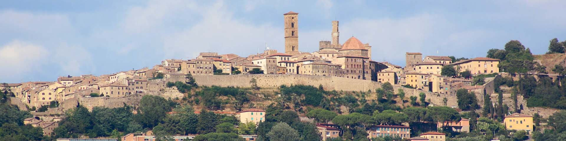
Volterra
Leonardo draws in detail, from different angles and assembly reconstructions, the Etruscan city of Volterra, on maps RL 12683 (from the east) and 12278, and mentions its strategic importance in relation to the Val di Cecina and the Valdera on the hydrographic map RL 12277. He also notes, in Madrid Ms. II (f. 3r), the observations made by him to find the geographical positions of the localities referred to, on the roads that from Montalbano run toward the Valdarno, the Monti Pisani and San Gimignano. Historically, the territory of Volterra was of interest to both Pisa and Florence, also for its mining resources.