

Arbia
Leonardo draws, on maps RL 12278 (indicating it twice) and RL 12277, the torrent Arbia which flows for 57 km through the Communes of Asciano, Buonconvento, Castelnuovo Berardenga, Gaiole in Chianti, Monteroni d'Arbia, Radda in Chianti, and Siena. Coordinates taken at San Fedele. Dante's famous verses: "The massacre and carnage\ which dyed the waters of the Arbia red, \ now make our temples cry out such decrees", Inferno, X, 85) refer to the battle fought on September 4, 1260, on the hill of Monteaperti between the Florentine Guelphs and the Sienese Ghibellines, whose troops had joined forces with those of Manfredi di Svevia and the political exiles from Florence led by Farinata degli Uberti.
Armaiuolo
Leonardo represents and indicates the stronghold of Armaiuolo, in the Commune of Rapolano Terme.
Asciano
Leonardo represents and indicates the stronghold of Asciano, a zone of Etruscan origins, along with the Communes of Castelnuovo Berardenga, Asciano and Rapolano Terme in the Upper Valley of the Ombrone. Interesting, in the Romanesque Pieve of Sant'Ippolito, is the "Madonna" attributed to Pinturicchio and, in particular, the figure of St. Ippolito previously attributed to Giacomo Pacchiarotti and more recently to Raphael.
Bagni di Petriolo
By 'Petriolo', Leonardo indicates Bagni di Petriolo (in the Commune of Monticiano), known already to the ancient Romans and mentioned by Ugolino of Montecatini in his 'Tractatus de Balneis' for the therapeutic properties of its suphureous waters. In 1404 the fortification of Bagni di Petriolo was completed, the only remaining example of fortified thermal springs. The Baths of Petriolo were frequented by such illustrious figures as Pope Pius II Piccolomini and Lorenzo de' Medici.
Bagni di San Filippo
Leonardo indicates the thermal locality of Bagni di San Filippo, in the Commune of Castiglione d'Orcia.
Buonconvento
Leonardo represents and indicates the stronghold of Buonconvento, along a level section of the Via Cassia, near the confluence of the Arbia with the Ombrone.
Camigliano
By 'Camignano', Leonardo represents and indicates the stronghold of Camigliano, in the Commune of Montalcino; the town, already existing in Etruscan times, is situated in hilly zone that overlooks the valleys of the Ombrone and the Orcia.
Capraia (Castle of)
By 'M. Caprajo', Leonardo indicates the Castle of Capraia, also called Montecapraio, Montecapraia or Montecaprile, in the Commune of Sovicille.
Castelnuovo Berardenga
Leonardo represents and indicates Castelnuovo Berardenga, in a strategic position for its location on the boundary of the territory.
Castiglione d'Orcia
Leonardo represents and indicates the castle of Castiglione d'Orcia, at whose top stands the Aldobrandesca fortress, opposite the nearby one of Tentennano at Rocca d'Orcia. Here are found the Romanesque church of Santa Maria Maddalena and the Pieve of Santi Stefano e Degna.
Cetona
Leonardo represents in singular manner (with a right angle) the walls of the castle of Cetona, which had developed in ancient times in concentric circles around the fortress. Contended by Siena, Perugia and Orvieto, the fortress was bought in 1418 by Braccio da Montone (a leading figure in the territorial organisation of Val di Chiana) and then, around 1458, was fortified by the Sienese with three gates and cylindrical towers.
Crevole
Leonardo represents and indicates the castle of Crevole, in the Commune of Murlo.
Cuna
Leonardo represents and indicates the fortified farm of Cuna (the Grange), in the Commune of Monteroni d'Arbia, on the ancient Via Francigena.
Farnetella
Leonardo represents and indicates the stronghold of Farnetella, in the Commune of Sinalunga.
Fontebecci
Leonardo represents and indicates the stronghold of Fontebecci, in the Commune of Monteriggioni.
Formone
Leonardo draws the course of the Formone on maps RL 12278 and RL 12277. The torrent flows through the Communes of Abbadia San Salvatore, Castiglione d'Orcia, and Radicofani. Coordinates taken at the point of confluence with the Orcia, in the vicinity of Gallina. Writes Repetti: 'The Formone, which still today constitutes the boundary of the Commune of Campiglia d'Orcia, seems to have served in the past as boundary between the Senese and the Orvietan territory, to the latter of which belonged Chiusino at the time'.
Fosini
Leonardo represents and indicates the stronghold of Fosini, in the Commune of Radicondoli. In ancient times it was the fortress (and then villa) of the Bishop of Volterra, at 639 meters above sea level, standing - writes Repetti - 'on a spur of rock projecting to the north-west of Monte Gerfalco, in the little valley of the torrent Pavone'.
Lucignano d'Arbia
By 'Lucignano di Val d'Arbia', Leonardo indicates the fortress of Lucignano d'Arbia, in the Commune of Monteroni d'Arbia.
Merse
By 'Mensa FL.', Leonardo indicates the course of the Merse (twice on map RL 12278 and once on map RL 12277), which flows through the Communes of Civitella Paganico, Montieri, Chiusdino, Montalcino, Monticiano, Murlo, and Sovicille. Coordinates taken at its confluence with the Ombrone (at the boundary between the Communes of Montalcino, Civitella Paganico and Murlo).
Monastero d'Ombrone
By 'Monistero', Leonardo indicates the Monastery of Ombrone, an ancient medieval stronghold of which we have information starting already from the 11th century. The place name 'Monasterio' refers to the nearby church of San Salvatore della Berardenga.
Montalcino
Leonardo represents and indicates the stronghold of Monalcino, still intact today, with the classic aspect of walled stronghold of pentagonal layout with towers at each corner.
Montefollonico
Leonardo represents and indicates the stronghold of Montefollonico, in the Commune of Torrita di Siena, in the vicinity of which he also draws the Sienese Montecchio.
Montelifrè
By 'Monte Lifrè', Leonardo indicates the castle of Montelifrè, in the Commune of Trequanda. Today, the remains of the ancient castle are visible only from the road.
Montepescini
This is one of the many castles (of which only the ruins are visible today (in the vicinity of Murlo (Fabbrichella, Formignano, Macereto, Montepertuso, Valresta, and Vescovado).
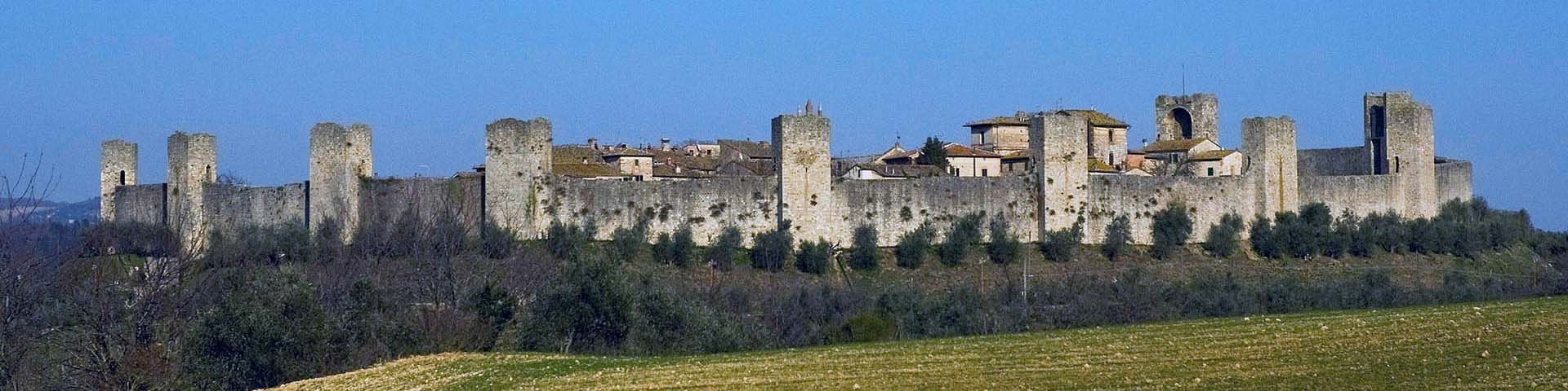
Monteriggioni
By 'Monte Raggioni', Leonardo indicates the castle of Monteriggioni, although without evidencing its admirable architectural features such as its ovoid shape and its 14 towers recalled by Dante (Inferno, XXXI) as resembling giants.
Monteroni d'Arbia
Leonardo represents and indicates the fortified mill of Monteroni d'Arbia, already a very important farm at the time of the ancient Sienese Republic.
Monticchiello
By 'Montecchiello', Leonardo indicates the walled town of Monticchiello, in the Commune of Pienza, a stronghold of the defensive structures positioned on the eastern boundary of the Sienese territory. A significant architectural structure is the church of Santi Leonardo e Cristoforo, which contains many frescoes of the Sienese school from the 14th and 15th centuries.
Monticiano
By 'Monte Acciano', Leonardo indicates the stronghold of Monticiano, originally under the jurisdiction of the Bishop of Volterra. It stands on a hill overlooking the course of the Merse river, a short distance from the Abbey of San Galgano.
Montisi
Leonardo represents and indicates the medieval town of Montisi, in the Commune of San Giovanni d'Asso.
Murlo
Leonardo represents and indicates the castle of Murlo, near the Arbia and, in the vicinity, indicates 'Munistero', probably to be identified as Vescovado di Murlo. Following the course of the Arbia and the Via Francigena, Leonardo indicates 'Montemurlo' further to the south.
Ombrone
Leonardo draws the course of the Ombrone as it flows through the Grosseto area, and indicates it twice as 'Ombrone' on map RL 12277 and as 'Onbron fl.' and 'Ombre fl.' on map RL 12278. The river traverses the Communes of Campagnatico, Cinigiano, Civitella Paganico, Grosseto, Scansano, Asciano, Buonconvento, Castelnuovo Berardenga, Montalcino, Murlo, and Rapolano Terme. Coordinates taken at Torre a Castello.
Orcia
Leonardo draws the course of the Orcia river and indicates it twice on map RL 12278 and once on map RL 12277. The river flows through Castel del Piano, Cinigiano, Civitella Paganico, Castiglione d'Orcia, Montalcino, Pienza, Radicofani, San Casciano dei Bagni, San Quirico d'Orcia, and Sarteano. Coordinates taken at the point of confluence with Ombrone near Casalone.
Paglia
Leonardo draws and indicates at two points the course of the Paglia, which flows through the Communes of Abbadia San Salvatore, Piancastagnaio, Radicofani, and San Casciano ai Bagni (where the coordinates were taken at the Ponte a Rigo locality).
Petroio
Leonardo represents and indicates the stronghold of Petroio, in the Commune of Trequanda.
Poggio Santa Cecilia
Leonardo represents and indicates the stronghold of Poggio Santa Cecilia, in the Commune of Rapolano Terme.
Ponte a Macereto
By 'Macereto', Leonardo indicates Ponte a Macereto, in the Commune of Monticiano.
Quercegrossa
Leonardo represents and indicates the stronghold of Quercegrossa, in the Commune of Castelnuovo Berardenga.
Radicofani
Leonardo represents and indicates the imposing fortress of Radicofani, which dominated the pass that marked the boundary between Tuscany and Lazio for centuries.
Radicondoli
Leonardo represents and indicates the castle of Radicondoli, on the Colline Metallifere (hills rich in metals) between Valdelsa and Val di Cecina. It was long a domain of the Sienese; consequently, its fortifications were partially demolished when it was conquered by the Florentines.
Rapolano Terme
Leonardo represents and indicates the town of Rapolano Terme, considered in the past the eastern boundary of the Republic of Siena.
Rosia
By 'Rossia', Leonardo indicates the stronghold of Rosia, in the Commune of Sovicille, where the torrent of the same name is found, across which stands the hermitage of Rosia, also called Santa Lucia.
San Lorenzo a Merse
By 'Foiano' (a medieval place name), Leonardo indicates the stronghold of San Lorenzo a Merse with its Romanesque church in the Commune of Monticiano.
San Quirico d'Orcia
A centre of Etruscan origin, occupying a strategic position between the Via Francigena and the road that, through Montepulciano and Pienza, led to Montalcino and then on toward Maremma. During the course of the 15th century, the town was rebuilt several times and its fortifications were reinforced.
Sarteano
By 'Sartiano', Leonardo indicates the stronghold of Saretano with the medieval fortress of the Manenti and the arc-shaped fortified village.
Selvole
Leonardo represents and indicates the stronghold of Selvole, in the Commune of Castelnuovo Berardenga.
Serre di Rapolano
Leonardo represents and indicates Serre di Rapolano, formally the seat of the Imperial governors in the 12th century, in the Commune of Rapolano Terme.
Siena
Leonardo represents with particular evidence Siena on map RL 12278, indicates it on map RL 12277 and mentions it on RL 12682; he recalls it in Ms. L on the second cover sheet ('Pagolo Vannoccio in Siena', father of the author of the treatise 'De la pirotechnia') and on folio 33v in connection with the bell of Sien. He also mentions it in two bibliographical references: an 'Opera of San Bernardino da Siena' (Madrid Ms. II, f. 2v) and perhaps a treatise by Ugo Benzo da Siena, 'Della conservation della sanità' (Codex Atlanticus, f. 559r). His participation in the Sienese cultural sphere of the early Renaissance was determinate for Leonardo, both for his technological studies and as mediator for his knowledge of the ancient authors (up to the Spiritali by Hero of Alexandria). The importance of the achievements of the Sienese engineers, from Taccola to Francesco di Giorgio (who was, moreover, his colleague in 1490 at Pavia, for the Fabbrica del Duomo) to Leonardo's scientific training is demonstrated by evidence from the codex in the Laurentian Library and from over 27 pages of notes found in Madrid Ms. II.
Subsequently, the painting of Leonardo influenced artists active in and around Siena, from Sodoma to Brescianino and Beccafumi.
Sinalunga
Leonardo represents and indicates the stronghold of Sinalunga.
Sovicille
Leonardo represents and indicates the stronghold of Sovicille, standing between the eastern part of the Sienese Montagnola and the Val di Merse.
Tocchi
By 'Tochi', Leonardo indicates the stronghold of Tocchi, in the Commune of Monticiano, in the valley of the Merse.
Torre a Castello
Leonardo represents and indicates Torre a Castello, in the Commune of Asciano.
Torri
By 'Torti', Leonardo indicates Torri, in the Commune of Sovicille, where Repetti mentions an ancient abbey of the Vallombrosian monks.
Torrita di Siena
Leonardo represents and indicates the stronghold of Torrita di Siena, in the Commune of Sinalunga, on maps RL 12278 and RL 12682.
Trequanda
By 'Treguanta', Leonardo indicates the stronghold of Trequanda. Probably by mistake, he replicates the indication in a position closer to Montepulciano.
Vignoni (Bagno)
By 'Vignone', in the Commune of San Quirico d'Orcia, Leonardo indicates Bagno Vignoni, a locality famed for its thermal springs already at the time of the Etruscans and the Romans, frequented also by Lorenzo the Magnificent. Between Vingoni and Radicofani, Leonardo indicates the locality of Capanne, close to the 'Paglia river'.
- Arbia (torrent)
- Asciano
- Bagni San Filippo
- Buonconvento
- Castelnuovo Berardenga
- Castiglione d'Orcia
- Cetona
- Grancia di Cuna
- Merse
- Montalcino
- Monteriggioni
- Monteroni d'Arbia
- Monticiano
- Montisi
- Murlo
- Ombrone
- Paglia
- Radicofani
- Radicondoli
- Rapolano Terme
- Rosia
- San Lorenzo a Merse
- San Quirico d'Orcia
- Sarteano
- Serre di Rapolano
- Siena
- Sinalunga
- Sovicille
- Torrita di Siena
- Trequanda
- Vignoni (Bagno)