

Ambra
Leonardo represents and indicates, on maps RL 12278 and RL 12277 (Windsor Castle), the course of the Ambra, which traverses the Communes of Bucine, Montevarchi, Terranova Bracciolini, Castelnuovo Berardenga, and Gaiole in Chianti. Coordinates taken at the exact point of confluence with the Arno, in the Levanella locality.
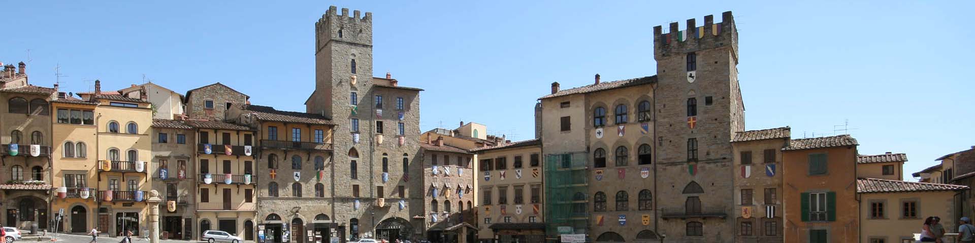
Arezzo
Leonardo represents Arezzo on maps RL 12278 and RL 12682 (Windsor Castle) and indicates it on map RL 12277, in the Codex Atlanticus (f. 127r) and in the Codex Leicester (f. 9A-9r). It is one of the most significant cities in Leonardo's Tuscany, also as regards the studies he carried out for the planned deviation of the course of Arno starting at least from 1495. Arezzo also played a strategic role of particular importance at the time of Vitellozzo Vitelli and the ephemeral lordship of Cesare Borgia, around 1502. Important also for its role of meeting place of roads leading toward Adriatic Italy, the city was embellished by famous masterpieces such as the cycle of frescoes by Piero della Francesca visible in the Basilica of San Francesco, which Leonardo probably had occasion to admire.
Bucine
Leonardo represents and indicates the stronghold of Bucine and indicates twice the presence of a Mill near it on the Chiani river.
Cozzano
By 'Cazano', Leonardo indicates the locality of Cozzano, near the torrent of the same name, which flows beside Castiglion Fiorentino.
Fontiano
Leonardo represents and indicates the stronghold of Fontiano, in the Commune of Arezzo, 'from which city it is 5 Tuscan miles to ostro' (Repetti, 'Dizionario geografico fisico storico della Toscana').
La Chiassa
Leonardo represents the torrent La Chiassa, which flows through the Communes of Anghiari, Subbiano, and Arezzo. The coordinates were taken at Giovi, point of confluence with the Arno.
Levane (ponte a)
By 'Ponte a Levane', Leonardo indicates Levane, on the Ambra river, between Montevarchi and Bucine.
Montebenichi
Leonardo represents and indicates the castle of Montebenichi, a twelfth-century medieval fortress, in the Commune of Bucine.
Montevarchi
Leonardo represents and indicates the castle of Montevarchi, a centre of trade in relation to the Via Cassia. In the Museum of Religious Art are the monumental "Tempietto" by the Della Robbia, coming from the Collegiate of San Lorenzo. In the Paleontological Museum are remarkable fossils from the Pliocene era.
Pieve a Quarto
Leonardo sketches and indicates the Pieve situated four miles from Arezzo. Here begins the sign of the route that, through Val di Chiana, arrives at Passignagno sul Trasimeno.
Pigli
Leonardo represents and indicates the stronghold of Pigli (in the past known also as Pilli), in the Commune of Arezzo, on maps RL 12278 and RL 12682 (Windsor Castle) at a distance of 6 miles from Castiglione.
Puliciano
Leonardo represents and indicates the stronghold of Puliciano in the Commune of Arezzo.
Quarata
Leonardo represents and indicates, on maps RL 12278 and RL 12682 (Windsor Castle), the stronghold of Quarata, in the Commune of Arezzo, in proximity to the Arno and to the Buriano bridge, which has recently been hypothesised to be the bridge appearing in the background of the 'Mona Lisa' in the Louvre.
Rigutino
By 'Rughettino' Leonardo indicates the stronghold of Rigutino on map RL 12278 (Windsor Castle), while on map RL 12682 he indicates the distance of three miles measured between Castiglion Fiorentino and 'Robuttino'.
Rocca Montanina
Leonardo represents and indicates the castle of Montanina on maps RL 12278, RL 12682 (specifying the distance of 4 miles from "Castiglione") and in the Codex Atlanticus (f. 918r). It is an ancient fortress of the Tarlati family from Arezzo, built in 1117, of which there remain only traces and ruins on the mountain of the same name to the east of Castiglion Fiorentino. The ruins of the castle may be reached from Val di Chio and from Santo Stefano, continuing up to the road-fork for Cantalena and then following the signs for "Rocca della Montanina".
Rondine
Leonardo represents and indicates the medieval stronghold of Rondine, in the Commune of Arezzo, on maps RL 12277 and RL 12278 (Windsor Castle).
San Giovanni Valdarno
By 'Castel San Giovanni', Leonardo indicates the fortified city of San Giovanni Valdarno, built by the Florentines in the 13th century to defend the Valdarno against Arezzo. The Palazzo della Podestà was built by Arnolfo di Cambio.
Vingone
Leonardo indicates the course of the Vingone, which flows almost parallel to the Cilone, between Montecchio and Castiglion Fiorentino. The coordinates were taken in the Chiani locality near the point of confluence with the Master Canal of Chiana. Not to be confused with the Aretine Vingone.
Vitiano
Leonardo represents and indicates the stronghold of Vitiano in the Commune of Arezzo on map RL 12278, while on map RL 12682 he notes: 'From Castiglione to Vitiano two miles'.