

Bientina
A historic centre of reference in Leonardo's projects for the Arno, in relation to the Padule, or marsh, of Bientina, known in the past as the "Lago di Sesto". We find Bientina on map RL 12685 (Windsor Castle), in the Codex Atlanticus and in Madrid Ms. II; the swamp or lake of the same name is also delineated by Leonardo, without naming it, on maps RL 12277 and 12279. In 1402 it was subjected to Florentine domination, except during the time of the incursion of Charles VIII into the territory of Pisa.
Calci
Leonardo indicates several times by the name "Calci" the locality to be identified with the famous medieval fortified castle and the Certosa, founded in the first half of the 14th century. By the place name "Val di Calci", mentioned in Madrid Ms. II (22v, 53r), in the Codex Atlanticus (f. 305r) and in the Windsor maps 12683 and 12277, he refers, instead, to the river and the road that traverse the valley known today as Val Graziosa. At the bottom of the valley, at a strategic crossroads, stands what was for Leonardo a reference point for calculating distances (RL 12279): Caprona with its defence tower, indicated also in Madrid Ms. II (ff. 1v, 22v, 53r).
Calcinaia
Calcinaia is represented by Leonardo in Codex Madrid II on folios 1r, 2r, 22v and 53r. Up until the second half of the 16th century Calcinaia actually lay on the south bank of the Arno, but the river’s course underwent various modifications over the centuries. The town, which in the 14th century still boasted a castle, underwent a gradual decline due to its dwindling population and transfer of the seat of the podestà (chief magistrate) to the town of Pontedera, of which Calcinaia gradually became a satellite. The war between Florence and Pisa contributed to this decline, and the village was definitively abandoned and re-established on a new site in the 1550s when Cosimo I and Ferdinando I decided to eliminate the bends in the Arno between Calcinaia and Giovanni della Vena.
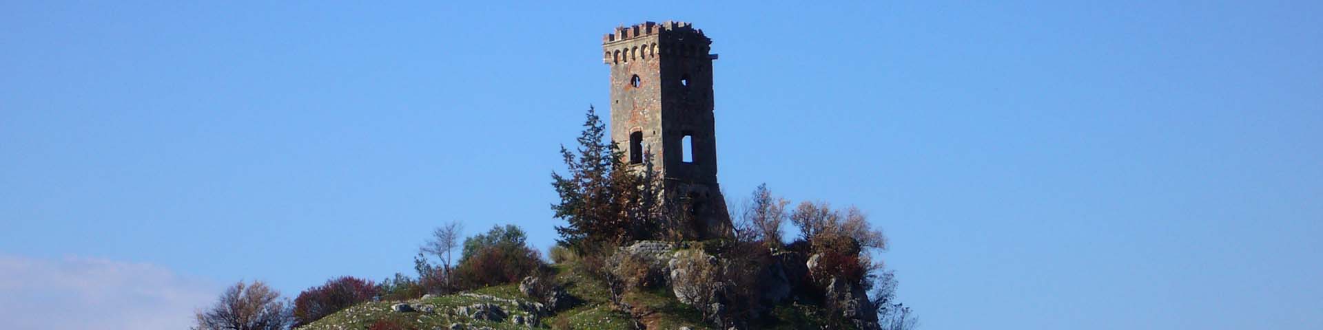
Caprona
Leonardo mentions Caprona in Codex Madrid II (ff. 1r, 8v, 22v, 53r) and on the map RL 12279 (Royal Collection, Windsor Castle). On the latter folio he writes, “They do not know why the Arno will never remain confined in a canal. It is because the rivers that flow into it deposit soil where they enter, and carry it away on the opposite side, causing the river to bend in that direction. The Arno flows for 6 miles between Caprona and Livorno; and for 12 across the marshes, which extend for 32 miles, and 16 from La Caprona on the river, which makes 48; the Arno from Florence for more than 16 miles; the distance to Vico 16 miles and to the canal is 5; between Florence to Fucechio the distance is 40 miles to the river Arno” . The castle, erected on the furthermost edge of Mount Verruca, was dismantled in 1433 by the Florentines. Dante, in a reference thought to be autobiographical, wrote, “Just so, I once saw soldiers fill with panic / As they filed from Caprona with safe conduct / Seeing themselves surrounded by their foes” (Inferno, XXI 95). A replica of this tower constructed in the 19th century but now reduced to a somewhat dilapidated state, can still be seen today overlooking a stone quarry on the road known as the Lungomonte running from Caprona to Pisa.
Cascina
By Cascina, Leonardo represents and indicates the city's fourteenth-century circle of walls, reference point for the studies and projects for deviating the Arno upstream of Pisa. He also mentions it on folio 305r of the Codex Atlanticus ("Casscina") and on several folios in Madrid Ms. II (1r, 2r, 7v, 16r, 22v, 53r). Particularly significant is the note on folio 7v of the latter codex, with the statement "Here is the view": from Cascina Leonardo studied and drew the Monti Pisani with the Verruca and the fortifications at the foot of the mountain on the other side of the Arno.
Dolorosa
The Sasso della Dolorosa is represented several times by Leonardo in the Codex Madrid II (ff. 1r, 3r, 8r, 8v, 22v, 53r). Rising 682 metres above sea level, it is one of the peaks of the sub-alpine mountain chain known as the Monti Pisani and from it descend the ridges that separate the valleys of Vicopisano, Buti and Calci. During its war against Pisa, in 1496 the Florentines constructed a defensive stronghold (of which only a few traces remain) on this peak. The name Sasso della Dolorosa (Mountain of Pain) could refer to the harshness of the surrounding landscape or to the deadly clash of arms that took place in 1496 when the Florentines attempted to take the Fortress of Verruca.
Foce
By "Foce", Leonardo indicates, on map RL 12683 (Windsor Castle), the tower at the mouth of the Arno (today Bocca d'Arno, near Marina of Pisa). On folios 3r and 52v of Madrid Ms. II he indicates the same locality as "Torre di Foce". It is and again "Foce" on folio 1v of the same Madrid Ms. and on folio 305r of the Codex Atlanticus. The base of this tower still exists today, but incorporated into a building dating from later times in the Torretta locality.
Montecalvoli
Montecavolo is cited by Leonardo on folios 1r, 2r, 3r and 22v in the Codex Madrid II. This hamlet with its castle played an important strategic role, above all in the battles between the cities of Florence, Pisa and Lucca. In 1431 the castle was used as a point of defense to block the passage of the Milanese troops led by Niccolò Piccinino. chorographic map appears in Ragionamento sopra le cause e sopra i rimedi dell’Insalubrità dell’Aria della Valdinievole by Targioni Tozzetti (Firenze, 1761, t. II) “… which starts from Calamecca, and continues as far as Montecalvoli, where the Gusciana, which is the point at which the Lake of Fucecchio drains into the Arno” (Domenico Moreni, Bibliografia storico-ragionata della Toscana o sia Catalogo degli Scittori che hanno illustrata la storia delle città…, Firenze, 1805, p. 379).
Montecchio
Leonardo represents and indicates the stronghold of Montecchio in the Commune of Castiglion Fiorentino on maps RL 12278, RL 12682 (Windsor Castle) and in the Codex Atlanticus (f. 918r).
Pisa
Leonardo represents and indicates several times the city of Pisa as one of the most important centres in his Tuscany, both for biographic reasons (his father Ser Piero had worked there as a notary) and artistic ones. In relation to the project for deviating the Arno, Pisa appears on maps RL 12683 and 12277 (Windsor Castle), in Madrid Ms. II (ff. 1v and 52r), and in the Codex Atlanticus (ff. 127r and 305r). Leonardo also mentions it for the cathedral and the bell tower on one of the folios removed from Ms. B. And again, around 1515, in relation to a map of the "plain of Pisa" (Codex Atlanticus, f. 225 r). On maps such as RL 12685 and 12279 the position of the city is indicated by a circle, but without place name, since it is clearly recognisable for Leonardo after the bend of Riglione. In Pisa worked and died (1553) Leonardo's nephew, Pier Francesco Da Vinci, known as Pierino, sculptor of the "Dovizia" in Piazza Cairoli and of the bas-relief "Cosimo de' Medici driving vice out of Pisa", now in the Vatican Museums.
Santa Maria a Monte
Leonardo mentions Santa Maria a Monte on folios 1r, 2r, 3r and 22v in the Codex Madrid II. This site was already inhabited in the 5th century BC. In the medieval period the town was dominated by a fortress with circular towers and was encircled by three rings of defensive walls, all of which are well conserved. It was a strategic military outpost that was fought over by Florence, Pisa and Lucca until the 14th century. With the victory of the Florentines in 1327 it gradually lost its strategic importance and the inhabitants began to build right up against the defensive walls. Michele Carducci, the father of the poet Giosuè Carducci, and Galileo Galilei both lived for a time in S M a Monte; a plaque indicates Casa Galilei while the residence of the former has been turned into a museum. Among the other monuments that stand out are the archeological park La Rocca, the medieval cistern, the Clock Tower, and the subterranean passageways. A municipal astronomical observatory is located in the nearby village of Tavolaia.
San Piero a Grado
By "San Piero in Grado", Leonardo indicates the Romanesque Basilica of San Piero a Grado (in the Commune of Pisa), a place of early Christian worship, frescoed by the painter from Lucca Deodato Orlandi. Leonardo mentions it also on folio 52v of Madrid Ms. II. It occupies a strategic position for controlling the Arno, as demonstrated by the decision of the Florentines to construct an "entrenched field" in this place during their sieges of Pisa.
Verruca
Leonardo indicates by "Verruchola" (or "Verrucha") the strategic fortress and the mountain of Verruca in the Commune of Calci. He draws on Madrid Ms. II and on Windsor paper RL 12683; and also mentions it on the Codex Atlanticus. The place is perhaps evoked in idealised form also in a drawing of an "Apocalyptic flood" dating from around 1516 (Windsor, RL 12385). On June 2, 1503 that Leonardo went to inspect the fortress, reconquered by the Florentine Republic, to plan its restoration.
Vicopisano
Leonardo indicates Vicopisano ("Vico") on map RL 12279 (Windsor Castle), in Madrid Ms. II (ff. 2r, 22v, 53r), in the Codex Atlanticus (f. 305r) and represents it, without specifying the name, on map RL 12683. In stenographic synthesis, he evidences the fortifications of Vicopisano with the great tower attributed to Filippo Brunelleschi. in the wars between Florence, Pisa and Lucca, this stronghold occupied an exceptional strategic position, being much closer to the Arno in the past.